See it in action
Draw odds, harvest data, unit profiles, and preference point analysis for elk hunting across 9 western states, all in one interactive map. No more jumping between PDFs and spreadsheets. Colorado apps open March 1st.
Enter your email and we'll send a reset link.
See it in action
Most hunters spend weeks bouncing between state PDFs, forum posts, and spreadsheets. This is what it looks like when all of that lives in one place.
Too many hunters spend years chasing 3% draw odds on "trophy" units, sitting out season after season waiting for a tag that might never come.
Here's the truth: you can't become a better elk hunter from your couch.
"Get a tag you can actually draw, get boots on the ground, and start learning. That's why I built this."
The experience you gain from a 60% draw odds unit where you actually get boots on the ground is worth more than a decade of waiting for a unicorn tag. This tool is built to help you find those opportunities: units where you can realistically draw, hunt, and learn. Across every western state that matters.
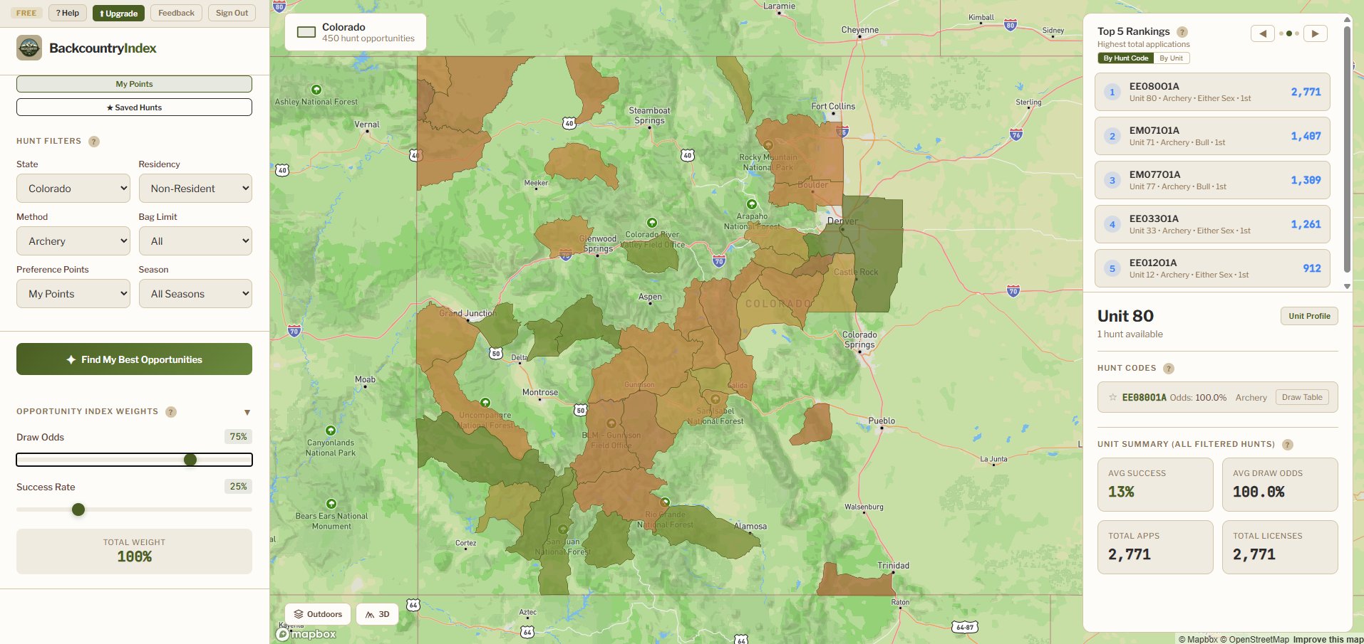
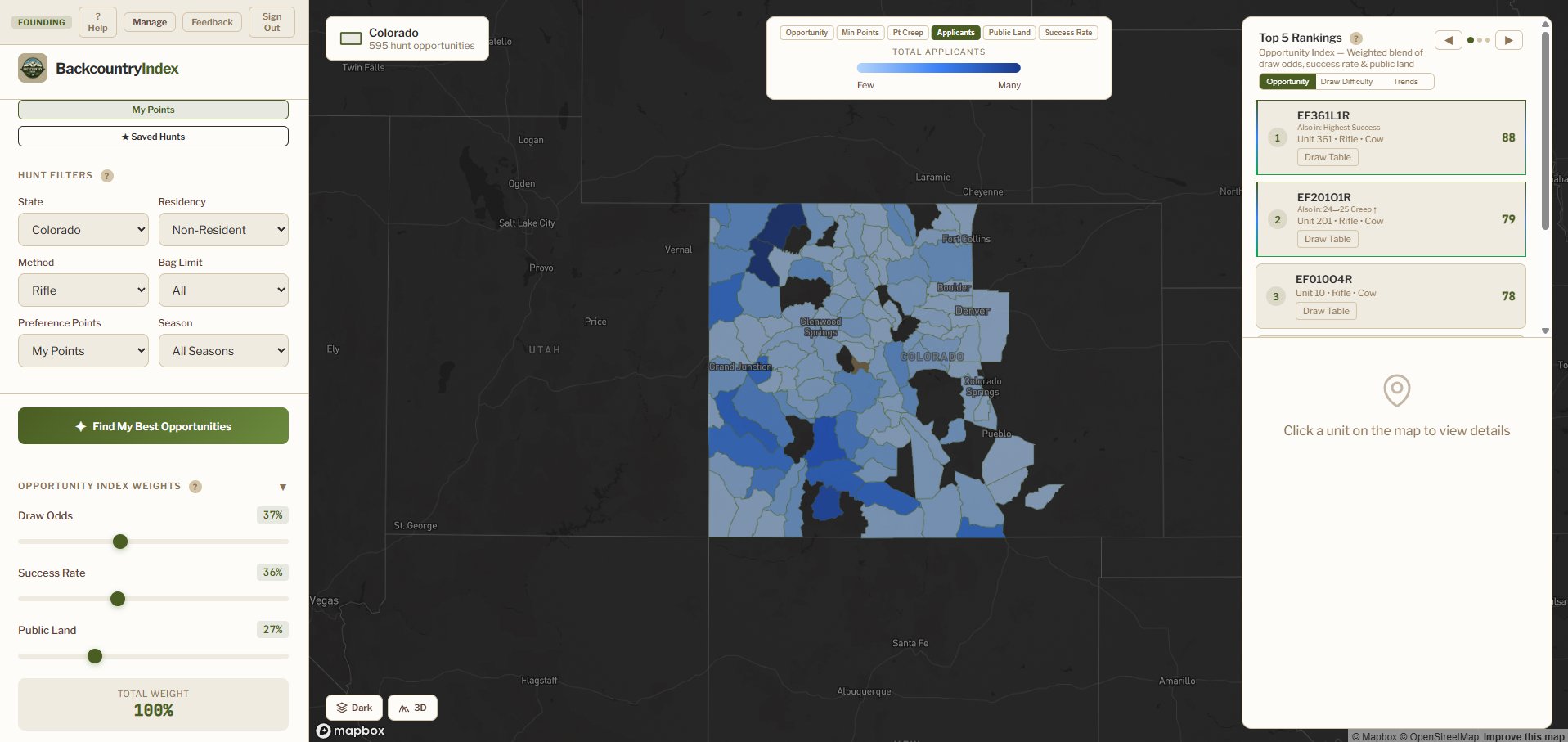
Everything loads in an interactive map. Filter by state, weapon type, residency, and more. No more cross referencing PDFs.
Every unit is color coded by a custom opportunity score that blends draw odds and harvest success rates. Adjust the weight sliders to match your priorities. Filter by weapon, bag limit, season, and residency.
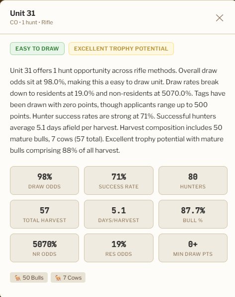
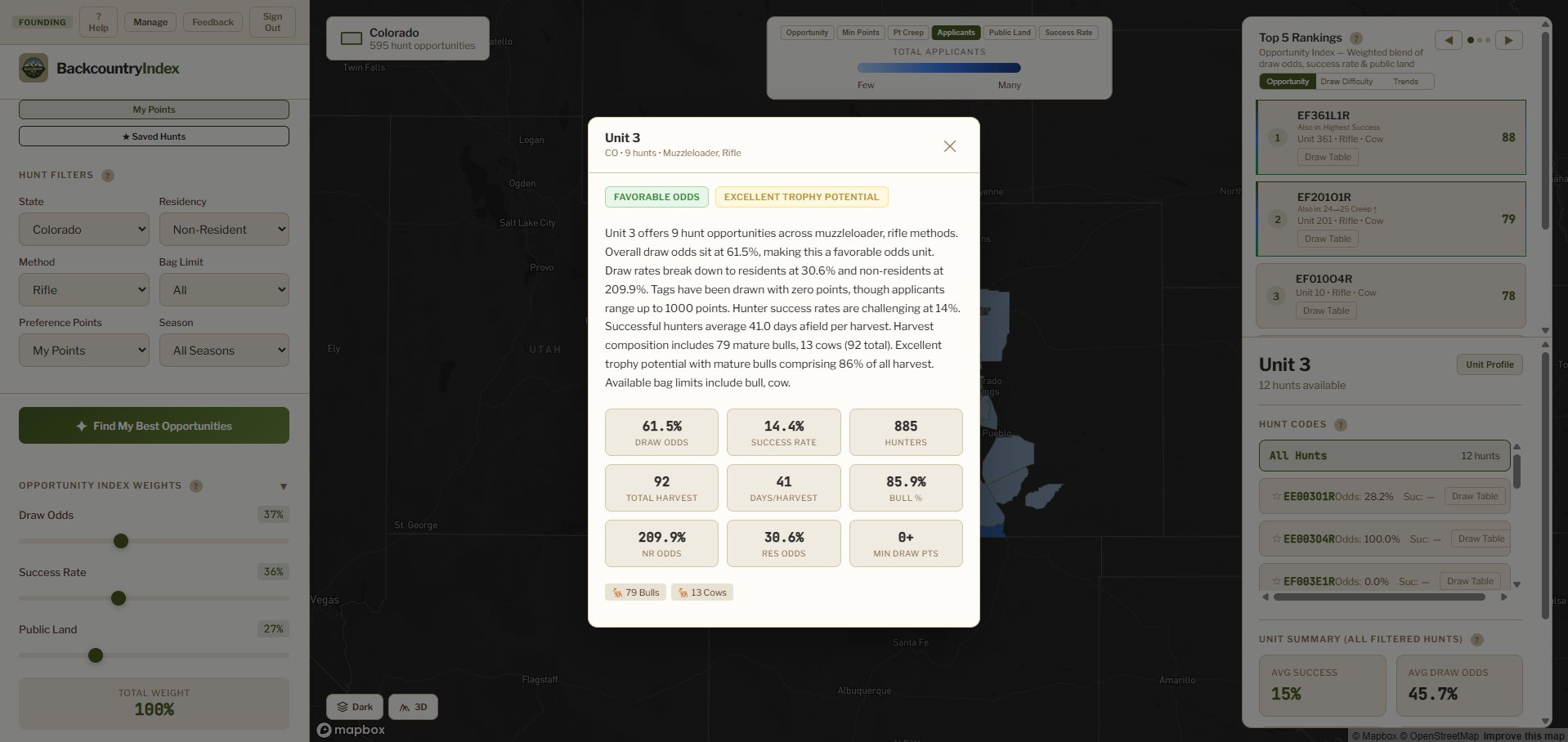
Tap any unit for a data driven breakdown including draw odds, success rates, hunter counts, days per harvest, and bull to cow ratios. AI summaries tell you what matters about each unit.
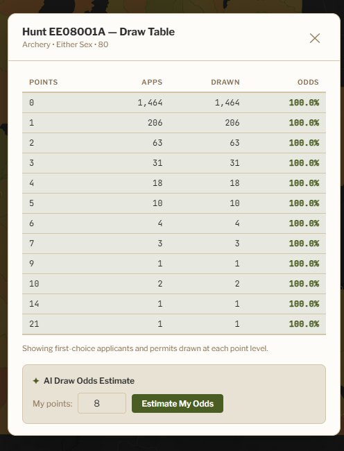
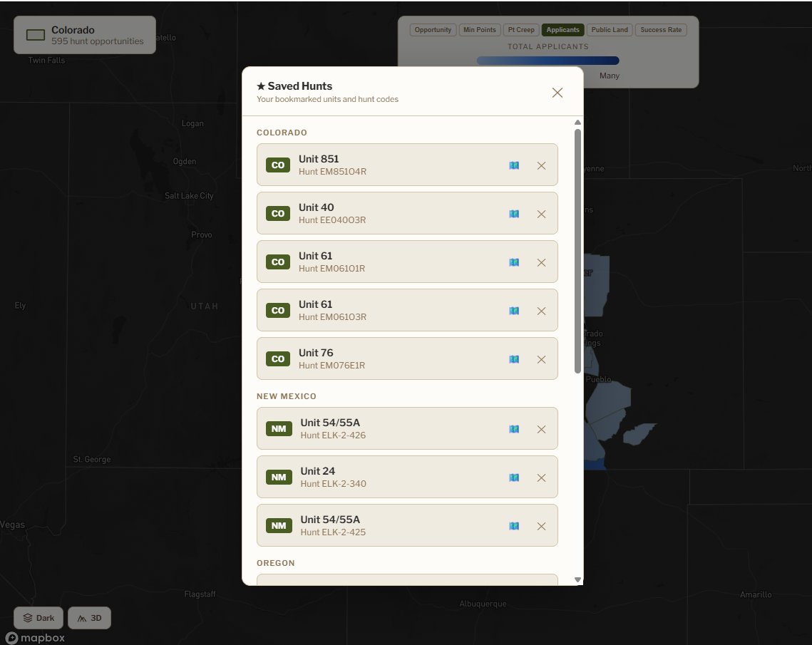
See exactly how many applicants applied and drew at every point level for each hunt code. Know whether your points make you a lock or if you still need to keep building.
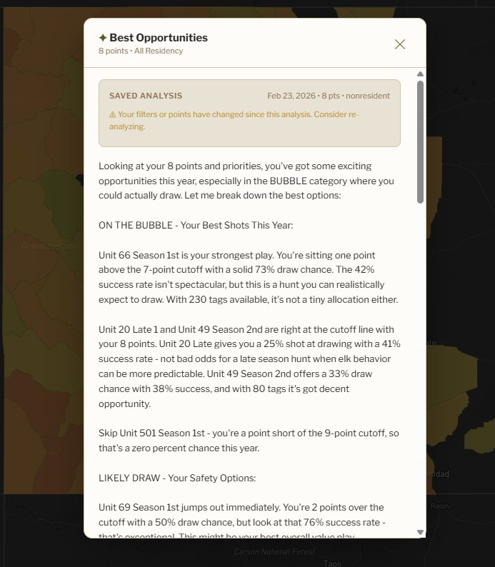
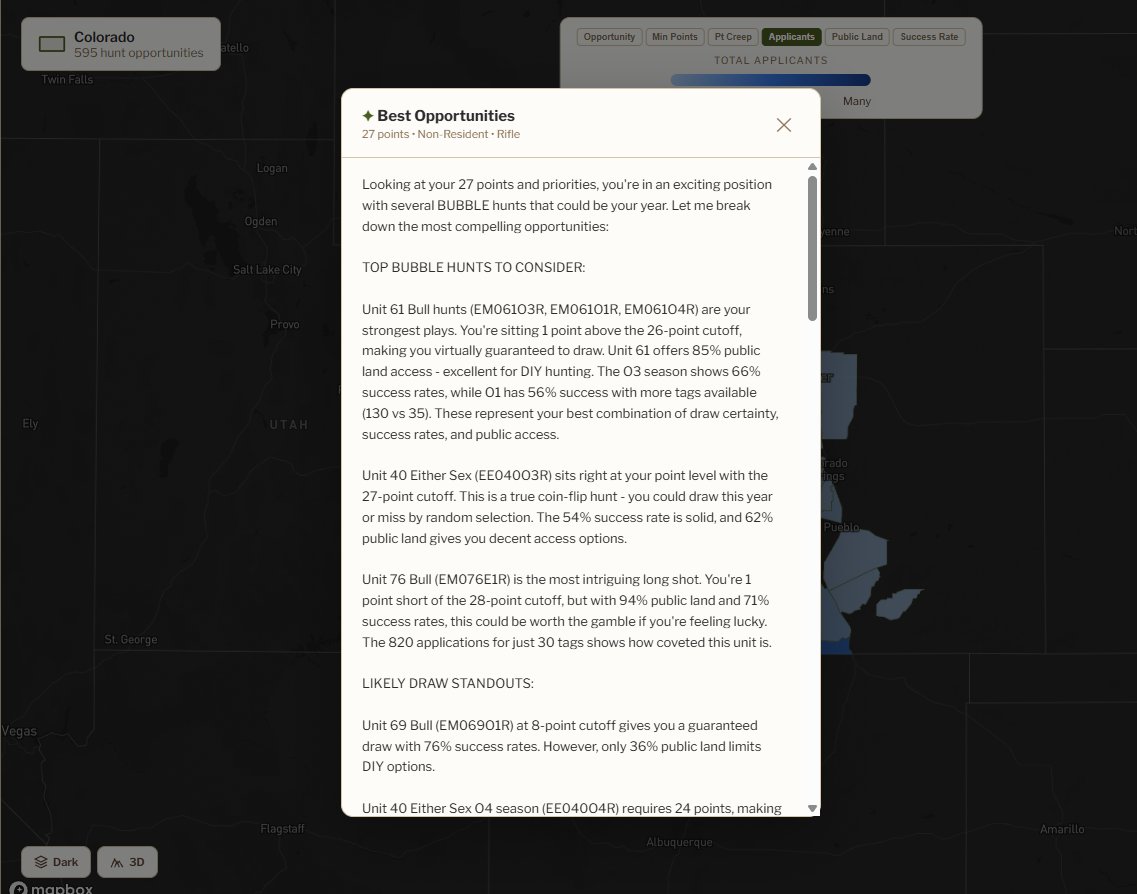
Enter your preference points and tap Find My Best Opportunities. AI analyzes every hunt against your point level to surface hunts where you are on the bubble, likely to draw, or worth building toward.
States covered: Arizona, Colorado, Idaho, Montana, Nevada, New Mexico, Oregon, Utah, and Wyoming. Data reflects the most recent available harvest statistics and draw results from each state agency.
Colorado is free forever. Unlock all 9 western states with a founding membership. Rate locked in for life. Founding pricing is limited.
Elk hunting research is a mess. Draw odds in one PDF, harvest stats in another, unit boundaries on a different map, preference point data in a spreadsheet you downloaded three years ago. I got tired of juggling tabs across eight different state websites, so I built what I actually wanted to use.
Everything lives in one interactive map now. Toggle between states, filter by weapon type and residency, compare draw tables across hunt codes, all without leaving the screen. No more cross referencing five different sources just to figure out if a unit is worth applying for.
The Opportunity Index is my own formula that weighs what actually matters: draw odds first, then success rate, then trophy potential. Because the most important thing is getting out there.
Real data from state fish and game agencies across the West. No AI generated heat maps, no "secret spots." Just the information you need to make smarter decisions about where to apply.
This is just the start. Here's what I'm working on next.
Live now. AZ, CO, ID, MT, NM, NV, OR, UT, WY with full draw odds, harvest data, and unit profiles.
Per point draw tables showing exactly what point level is drawing tags for each hunt code.
Predictive models analyzing point creep trends and draw probability. Know where to burn your points before everyone else figures it out.
Mule deer, antelope, and moose data using the same framework. Same tool, more species.
Expanding coverage based on member demand. Every new state included with your membership.